By, uav-jp
06/05/2022
Skymatics, which solves all social issues with remote sensing, raised 1.3 billion yen to a cumulative total of about 2.9 billion yen
Accelerate DX promotion by "space-time analysis platform"
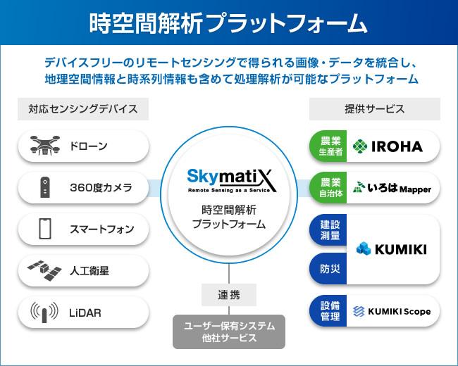
Skymatics Co., Ltd. (GIS *) × Skymatics Co., Ltd. (Chuo-ku, Tokyo, Representative Director Zentaro Watanabe), which solves all social issues with a "spatio-temporal analysis platform" that processes and analyzes time-series information, Femto Growth Fund 2.0 Investment Business Limited Liability Association of existing investors, new investor Milliteron, Japan Coin Best (operator: Sumitomo Mitsui Trust Investment), and Agriculture and Forestry Central Bank Through a three-party allotment, we raised a total of approximately 1.3 billion yen. With this series B procurement, the total amount raised has reached approximately 2.9 billion yen. Based on the funds raised, we will further strengthen the "spatio-temporal analysis platform" and promote sales expansion of services and recruitment of human resources. * GIS: Geographic Information System, a system that manages and processes geographic information and its accompanying information on a computer We are a technology startup with the mission of "creating a new society through remote sensing". Remote sensing is a technology for observing objects from a remote location using a sensor. We are building a "spatiotemporal analysis platform" by reproducing the information acquired by remote sensing on the Web using Geographic Information System (GIS) technology and combining time-series information. Through the "spatio-temporal analysis platform" that processes and analyzes all geospatial information and time-series information, we are promoting problem solving and DX in a wide range of industries such as agriculture, construction, surveying, equipment inspection, and disaster prevention. The business is growing rapidly against the backdrop of accelerating the promotion of DX in Korona-ka, solving social issues such as a decrease in the working population and improving productivity, and increasing interest in the SDGs. Among our services, the smart agricultural service "Iroha" for farmers, the agricultural management DX solution "Iroha Mapper" for local governments, the drone survey / local management DX cloud "Kumiki", and the facility / equipment information management system "Kumiki" We have received a large number of inquiries regarding "scope". The funds raised this time will be concentrated on sales and marketing of these services, and will be used to strengthen recruitment. Regarding recruitment, we plan to further expand R & D personnel and sales / customer success personnel, centered on GIS engineers, WEB engineers, and image processing analysis engineers. Drone surveying / local management DX cloud "Kumiki" "Kumiki" is a site data management service that has all the functions necessary for managing site data, from drone survey data to image / video data for site confirmation. By visualizing the on-site data that was previously managed separately on a map, the data management of the on-site staff is overwhelmingly efficient, and the head office and the ordering party do not have to go to the site. You can get the details. Currently, it has been introduced in 17 industries such as the construction industry, crushed stone industry, and local governments, and at many sites, the load of data management work has been reduced and information sharing has become smarter. ■ Drone survey of "Kumiki" ■ Time-series on-site data management by "Kumiki" "Kumiki" service introduction: https://smx-kumiki.com/ Notice of major update of "Kumiki": https //prtimes.jp/main/html/rd/p/000000049.000025718.html Facility / equipment information management system "Kumiki Scope" "Kumiki Scope" is a facility that manages all facility / equipment information smartly and efficiently.・ Equipment information management system. By visualizing information such as images, texts, files, etc. related to disjointed facilities and equipment on a 360-degree panorama of indoors and outdoors from drone images and 360-degree camera images, it is easy without going to the site. And it can be managed and confirmed efficiently. Furthermore, by image processing analysis using original AI, it is possible to perform detection and diagnosis necessary for equipment inspection such as "rust detection" and "corrosion diagnosis". It is currently being introduced in the chemical, electric power, and shipping industries. ■ Indoor / outdoor 360-degree digital twin "Kumiki Scope" service introduction by "Kumiki Scope": https://smx-kumiki.com/psv/ Smart agricultural service for farmers "Iroha" "Iroha" is a state-of-the-art image It is a smart agricultural solution that realizes a new era of agricultural standards with analysis technology and geographic information technology. By using satellite images and drone images, it is possible to grasp the entire vast farmland in an instant, and bring about a new concept of patrol that "do not go to farmland". In addition to being selected by farmers nationwide and achieving a prefectural penetration rate of 100%, it has also been adopted by many local government projects such as the Ministry of Agriculture, Forestry and Fisheries Smart Agriculture Acceleration Demonstration Project. ■ Growth diagnosis "Iroha" service introduction by "Iroha" farmland image analysis: https://smx-iroha.com/top.html Agricultural management DX solution for local government "Iroha Mapper" Management income stabilization measures and mountainous areas in local governments It takes a lot of manpower and time to conduct a field survey for direct payment in areas. With "Iroha Mapper", it is possible to save a lot of labor by realizing a DX that summarizes billing, field surveys, and confirmation results. All the local governments that have introduced it so far have realized that it saves 70% of the labor compared to the past. ■ Field survey by image analysis of "Iroha Mapper" "Iroha Mapper" service introduction: https://smx-iroha.com/mapper/ ■ Femto Partners Co., Ltd. Principal Shingo Yamada We made an additional investment following the previous series A round. I did. Since the last round of financing and MBO, with the help of everyone, mainly the management team, the business domain and services have been further expanded, and strong growth has continued. We expect that we will make a leap forward as a platform company that solves problems in each industrial field such as agriculture, surveying, inspection, and disaster prevention by leveraging our unique image analysis / AI and GIS technology using them. increase. ■ Mr. Mizuki Inoue, General Partner & CEO of Milliteron Co., Ltd. Skymatics enables the acquisition and analysis of physical data in a wide range of fields such as agriculture, construction, surveying, and disaster prevention with its high technology, and the decrease in the working population and productivity facing Japan. We recognize that we are the one and only company that can solve urgent social issues such as improvement. Judging that its high growth potential and great potential are suitable for our first investment project, we participated in this round as a lead investor. I hope that he will play an active role as a data platformer representing Japan in the future, and I would like to work together to realize it. ■ Sumitomo Mitsui Trust Investment Co., Ltd. Director David Seu Our fund in the Japan Coin Best series aims to invest in ventures with high growth probability. We hope that the platform based on the advanced technology of image processing analysis and spatial arithmetic processing of Skymatics will become a tool that anyone can use anytime, anywhere, with the industrial innovation by remote sensing close to us. ■ Mr. Koichi Akiyama, Senior Manager, Sales Planning Department, Norinchukin Bank The Norinchukin Bank has invested in Skymatics Co., Ltd. through the “F & A Growth Industrialization Investment Frame”. Smart agricultural services such as "Iroha" and "Iroha Mapper" respond to social issues such as a decrease in the working population at agricultural production sites that are becoming larger in scale and administrative sites that support them, and contribute to improving productivity in the agricultural field. I think that it will be done. Taking this investment as an opportunity, we will contribute to solving problems by deepening cooperation that makes use of our strengths and our network in terms of social sustainability, response to natural disasters, efficiency improvement by utilizing digital technology in the food and agriculture value chain, etc. I will come. In the future, such corporate investment related to food and agriculture will be made through AgriBusiness Investment Development Co., Ltd., a group company that has traditionally invested in agricultural corporations, and synergies with the investment development business for producers will be made. We will continue to work on the development of agriculture, forestry and fisheries, food industry, etc. We are a technology startup with the mission of "creating a new society through remote sensing". Remote sensing is a technology for observing objects from a remote location using a sensor. We are building a "spatiotemporal analysis platform" by reproducing the information acquired by remote sensing on the Web using Geographic Information System (GIS) technology and combining time-series information. The essence of our service is "to make the invisible visible." As it is said that 80% of the information that people receive is from the visual sense, people basically act and make decisions based on what they can see. However, people cannot wake up 24 hours a day, 365 days a year, and cannot see outside of sight. It is also difficult to recognize and judge multiple events in an instant, and to memorize and compare all past events. Remote sensing is a technology that solves these constraints on human time, space, and ability, and is our "spatio-temporal analysis platform." Through the "spatio-temporal analysis platform," we can provide not only information that could not be obtained without actually going to the site, but also information that could not be obtained by the human eye, and a perspective different from the human eye. increase. "Making the invisible visible" not only makes work more comfortable and efficient, but also changes people's decisions and behaviors, creating a new future for society. We believe we can contribute. Skymatics implements remote sensing in the world's best society and creates a new society. We are building a "spatio-temporal analysis platform" based on an innovative original technology that integrates "image processing analysis, AI x spatial arithmetic processing, WebGIS x time-series information processing". Through the "spatio-temporal analysis platform," not only will the work that people have been doing on-site to be significantly shortened and labor-saving, but also new information and perspectives that have not been available to the human eye will be provided. We provide our own services like this. In order to become a top runner of GIS services, we are looking for members in many positions including GIS engineers in order to implement remote sensing in the world's best society and create a new society. ■ GIS engineer The main business is technology selection, design and development of in-house remote sensing service utilizing drone images and satellite images, and it is an environment where you can work with top engineers who have abundant product development experience in the space industry and GIS industry. You can gain a wide range of GIS technical experience such as spatial analysis, time series information analysis, 3D data maintenance and utilization, and GIS programming. We hope that you will be actively involved in adding functions and proposing improvements, and that you will be able to play an active role as a product owner. ■ Web engineer You will be involved in the design, implementation, operation, and maintenance of your own remote sensing service. The main business is the development of Web applications (own products and services) and the design and development of the front end. We also expect to be involved in the planning and development management of services and products. ■ PdM Product Manager You will manage the design, planning, and development from the requirement definition of your own remote sensing product. We welcome you to play an active role as a product owner. ■ R & D Researcher We are looking for people who can promote R & D for the purpose of further growth as an in-house service, not as a contracted project or PoC. Approximately 20% of our employees are R & D members, and we are putting considerable effort into applying advanced technology. We are mainly engaged in research and development related to SfM / MVS, development of elemental technologies for 2D / 3D data processing analysis, and research on advanced technologies. You can even experience implementing your own research and development technology in your own products and providing services. ■ Sales Manager We are looking for someone who can lead the management of DX service sales teams, agency management, business collaboration with other companies, etc. in a wide range of industries such as agriculture, construction, surveying, equipment inspection, and disaster prevention. ■ Customer success For those who can grasp the problems and improvements that users want to solve, make additional proposals for our services to solve them, and provide support and case studies for service utilization as "accompaniers" by making full use of digital technology. We are recruiting. The final step is to create a foundation for grasping and managing issues, which is necessary for "accompaniment", planning and tooling approach methods based on the user's situation, and involving all user contact points such as sales, customer support, and marketing. I expect that it will play a role in creating, deploying, and executing a framework for achieving success. We are strengthening recruitment in a wide range of positions other than the above, so please visit the recruitment site ( https://skymatix.co.jp/smx-recruit/ ). Company name: Skymatics Co., Ltd. Location: 4-2-16 Nihonbashi-Honbashi-cho, Chuo-ku, Tokyo Daiwa Nihonbashi-Honbashi-cho Building 6F Representative: Zentaro Watanabe, President and CEO Business description: Planning, development and sales company URL of industrial remote sensing service : Https://skymatix.co.jp/ Recruitment site: https://skymatix.co.jp/smx-recruit/note: https://note.com/skymatix/ Contact: info@skymatix.co. jp * The following is special information limited to media personnel. Please refrain from disclosing information on personal SNS etc.This press release contains information for the media.
If you register as a media user, you can view various special information such as contact information of the person in charge of the company and information on events and press conferences. * Contents vary depending on the press release.
- Press Release>
- Skymatics Co., Ltd.>
- Skymatics, which solves all social issues with remote sensing, raised 1.3 billion yen to a cumulative total of about 2.9 billion yen
